Key points
- Leveraging transportation data in "what-if" scenario simulations - especially in high-risk contexts such as global conflicts - allows shippers to anticipate and mitigate potential disruptions in supply chains
- Advanced data analytics enable companies to model various scenarios, providing insights into the impacts of different logistical decisions
- These simulations allow for proactive risk management by identifying vulnerabilities and testing the effectiveness of contingency plans
- By integrating real-time data, businesses can enhance decision-making processes and improve overall supply chain resilience.
Global geopolitical disruption just stepped up another level this week. All-out war between Israel and Iran may have been averted by a June 24 ceasefire… and yet Israel said this was not respected by Iran just hours after it was announced.
Such unprecedented uncertainty means shippers and carriers alike must be on full alert at all times, and ready to change plans at the last minute, in order to minimize supply chain impacts. Let’s take a look at one of these potential impacts - the closure of the Strait of Hormuz - and how real-time transportation visibility (RTTV) can help…

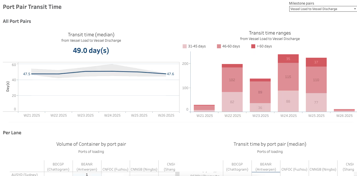
This dashboard helps simulate the impact of rerouting, by showing how long containers actually take to move between load and discharge ports (as opposed to just planned durations). By analyzing historical median transit times and their variability per week, planners can compare baseline performance across lanes (e.g. Chattogram to Antwerp vs. Fuzhou to Bremen) and assess the feasibility of alternate port combinations in a crisis scenario.
During a disruption like the potential Hormuz closure, it allows simulation teams to test the scenario “if we divert to Port X, how much extra time will that add?” and anticipate which port pairs are most resilient or overloaded and decide then on which components or customers orders you need to book expedited shipments.
Short-term simulations
In the immediate aftermath of a closure of this importance, companies face dynamic rerouting needs, port congestion, and limited visibility into where shipments are stuck or diverted.
Here's where real-time transportation data becomes a lever for control:
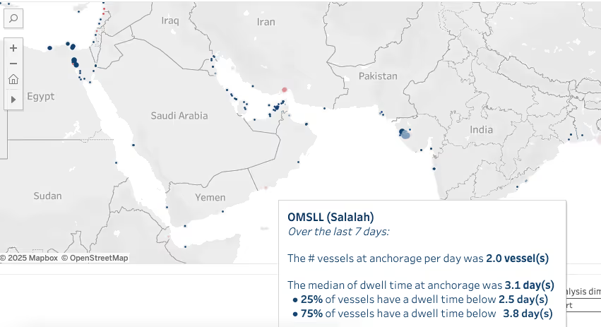
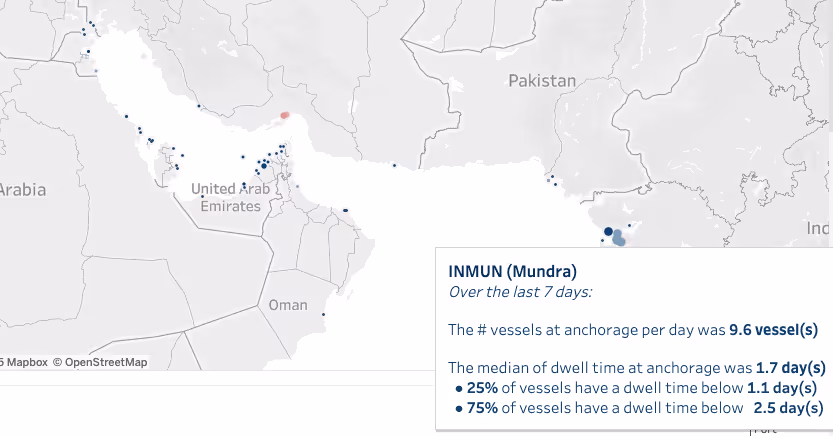
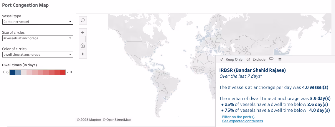
- Predictive congestion insights: With alternate ports like Mundra or Salalah suddenly receiving abnormal volumes, data on port throughput, dwell time, and anchorage queues becomes essential to avoid bottlenecks
- ETA accuracy and vessel re-sequencing: As ocean schedules shift due to detours, transport planning teams must rely on precise ETAs, not static carrier schedules, to recalibrate production, inland dispatch, or handovers
- Container positioning: Shortages of empty containers—caused by imbalances at Gulf ports—can only be mitigated if shippers and 3PLs track container flows and reposition assets using fleet-level container movement data
- Overland logistics visibility: With imports rerouted through Oman or Saudi Arabia, cross-border trucking visibility becomes essential to identify jammed corridors and adjust lead times.
In such a volatile phase, absence of transport data leaves planners blind, making every day costlier than the last.
Long-Term simulations
If the closure risk persists and a major shipping incident is confirmed, new trade lanes might appear. Shipping alliances may apply new charges on the traditional lanes, Gulf ports might lose handling volume or new overland corridors can be used to bypass the strait.
In case of such major structural changes:
- Historical transit time data supports new routing decisions (for example, might it be more affordable and reliable to use smaller feeder vessels via a safer port like Duqm than to go through Dubai?)
- Lane-level performance metrics help select alternate ports based on reliability and and resilience (how fast the berth dwell times were back to normal)
- Carrier performance and leadtime accuracy performance allow freight professionals to contract smarter, factoring in not just freight rates but geopolitical exposure.
Most importantly, transportation data enables scenario modeling. Take questions such as:
- “What if Jebel Ali is bypassed?”
- “What if India–Gulf corridors overland outperform Suez-based maritime?”
Without clean, historical data, questions such as these become guesses.
Conclusion: Transport Data Is the New Navigational System
In the risk of a Hormuz closure scenario, disruptions force both immediate reaction and long-term adaptation. In both cases, transportation visibility is not a nice-to-have - it becomes the navigational system of the entire supply chain, turning static planning into a dynamic process that adapts in real time.
In this context, investing in transport data infrastructure is as strategic as diversifying suppliers or building physical inventory buffers. When chokepoints collapse, data keeps the flow alive.
Latest blogs & product releases.
Authors


Frequently Asked Questions
What are "what-if" scenario simulations in transportation?
"What-if" scenario simulations use transportation data to model potential future events, helping shippers anticipate and prepare for various logistical challenges.
How can transportation data improve supply chain resilience?
By analyzing transportation data, companies can identify vulnerabilities, test contingency plans, and make informed decisions to enhance supply chain resilience.
What role does data analytics play in these simulations?
Data analytics processes vast amounts of transportation data to create accurate models and provide actionable insights for strategic planning.
Why is real-time data integration important in scenario simulations?
Real-time data integration ensures that simulations reflect current conditions, allowing for more precise predictions and timely responses to potential disruptions.