The Global Positioning System (GPS) is a satellite-based navigation system made up of at least 24 satellites. The system was made available for civilian use in the 1980s, and with the explosion of ‘location-aware’ devices such as smartphones over the past decade, it has enabled a revolution in location and ETA tracking services. However, GPS has some limitations that need to be thoroughly understood and accounted for in data cleaning processes in order for GPS location data to be as accurate and reliable as possible. Real-time transportation visibility platforms with poor data cleansing practices and which receive GPS positions in batches and at low frequencies will struggle to produce accurate and reliable ETAs.
GPS location data retrieved from telematics devices are prone to inaccuracies due to some technological limitations. Here are some common environmental factors affecting location and timestamp accuracy:
- Electromagnetic activity: The particles in the upper section of the earth’s atmosphere are highly affected by changes in solar energy levels. As the charge of particles changes, it creates a ‘lens’ effect on the GPS radio waves travelling through, which results in slight ‘bending’ of the signal, leading to an inaccurate result
- Fluctuations in atmospheric humidity and pressure: Changes in moisture and density in the lower atmosphere can create a similar lens effect to electromagnetic activity, mentioned above.
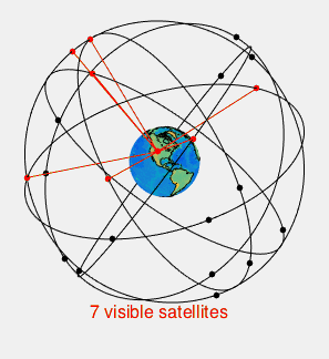
- Distribution of satellites: GPS satellites are constantly in orbit around the Earth. A GPS device usually needs to receive signal from at least 7 or 8 satellites in order to calculate location to within 10 meters. GPS typically won’t work at all with less than 4 satellites.
- Urban canyons: these refer to streets lined with buildings, which create a ‘canyon’ effect, shadowing streets and blocking out satellite signals.
- Multipath effect: as a vehicle travels through an urban canyon, GPS signals can sometimes reflect off of buildings down onto receivers below. Because the signal has been reflected, it can record an inaccurate location.
- Time to First Fix: the time taken to acquire GPS signals from when the device is turned on. Mobile phones take advantage of local mobile network signal to help speed up this process, using ‘Assisted GPS’ or AGPS
- Malfunctioning telematics devices: technical faults within the receiver can lead to inaccurate readings
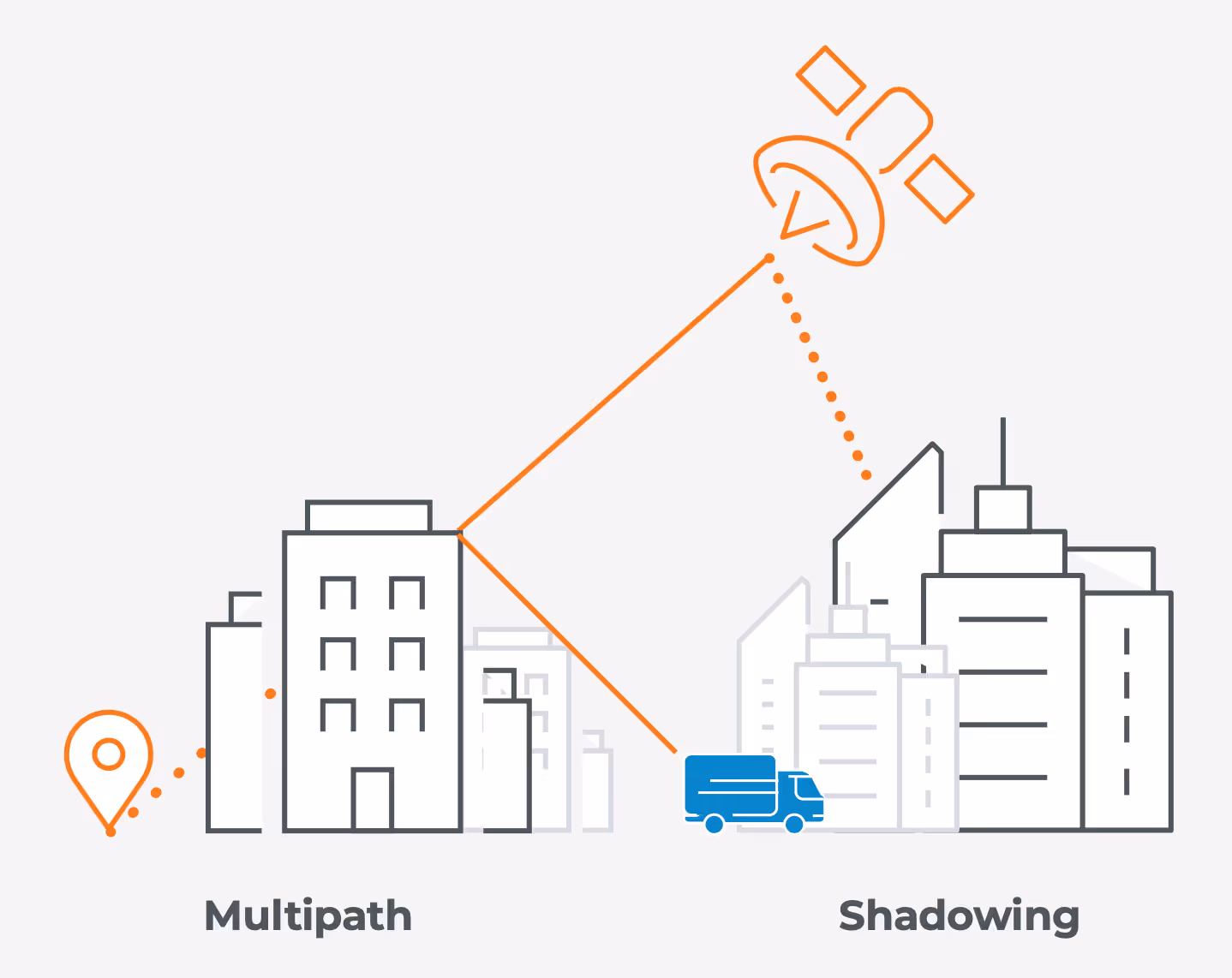
- Shadowing can lead to a low number of available satellite signals, preventing an accurate position being obtained
- Multipath effect, caused by signals bouncing off of buildings, causes the receiver to record an inaccurate position sometimes by several meters, even when there are a high number of satellite signals available
In road transportation visibility solutions, GPS position accuracy is critical. The status of a shipment or delivery is automatically determined based on the position of trucks (telematics systems) in relation to key sites. These sites can include factories, warehouses, distribution centers, cross-docks, retail outlets, etc. Each of these sites is surrounded by a ‘geo-fence’, which represents the site’s immediate surroundings. As soon as a truck’s GPS reports a location within a ‘geo-fenced’ area, it triggers an automatic notification in real-time to update the status of the shipment. For example, ‘arrived on site’ or ‘left the site'. In addition, if the GPS signal is not cleansed, it's difficult to determine whether the driver is idle or driving, and at what approximate speed, which directly impacts ETA accuracy.
Without expert data cleaning, the reliability and usefulness of real-time transportation visibility solutions suffers, reducing accuracy of the information shared to collaborators throughout the supply chain, and limiting value added. For these reasons, platforms should be sophisticated enough to filter and clean the raw GPS signal data in real-time to obtain a time series of a “smoothed” GPS signal, in turn limiting inaccuracies in location data and the ETAs presented to users.
With the advent of machine learning, and development of advanced algorithms, data cleansing processes can be automated, allowing for powerful data transformation. For instance, Shippeo’s platform automatically compensates for issues such as multipath effect and time to first fix. Filtering, smoothing and de-noising algorithms need to be used to cleanse GPS signal for ETA calculations. Without this automation, such calculations would be overwhelmingly complex for an individual to perform.
Harnessing this technology demands strong expertise. At Shippeo, an in-house team of data scientists and data engineers have implemented a proprietary algorithm to carry out the advanced computations required in real-time. The team has worked on the architecture of their machine learning model over the past 2 years, using cutting edge techniques. This development takes a vast amount of manpower and time, with over 1500 man-hours invested into Shippeo’s algorithm alone.
For a more in-depth and technical discussion around how Shippeo’s data team overcome imperfect data challenges (like raw GPS signal) to produce best-in-market ETA accuracy and reliability, please reach out to our team of experts.
Latest blogs & product releases.
Authors